What will the future of North Bay coastal communities look like in the coming decades if predicted sea-level rise continues unabated?
That’s what the Marin community of Stinson Beach has been asking, as it draws down on a three-year project to consider options for stemming the tides of the Pacific Ocean from eventually inundating the community of 366.
A recently published report plans for a rise in sea levels of 3.3 feet by 2085 and introduces a new framework called an “adaptation pathway” to help Stinson Beach residents and local agencies take appropriate action to respond. The study is a culmination of findings led by Stinson Adaptation and Resilience Collaboration, or Stinson ARC, a non-regulatory committee of local stakeholders.
According to the report, those actions include raising roads, bridges and homes; elevating infrastructure like the Seadrift and Bolinas lagoon bulkheads; building dunes and cobble berms along beaches to create natural buffers; and transitioning to a community wastewater treatment system.
The plan was developed with the input of community stakeholders, with an eye on engineering, environmental, regulatory, social and economic considerations, said Marin County Community Development Agency Assistant Director Chris Choo. Consulting firm Environmental Science Associates were engaged to identify and analyze feasible adaptation strategies.
Sea-level watchdogs consider Stinson Beach to be West Marin’s most immediately at-risk community—and long-term coastal flooding continues to create complications for local residents, beach visitors and natural habitats. The popular beach town averages between 600,000 to 1 million visitors per year, according to data from a Stinson ARC beach-user report and the National Park Service.
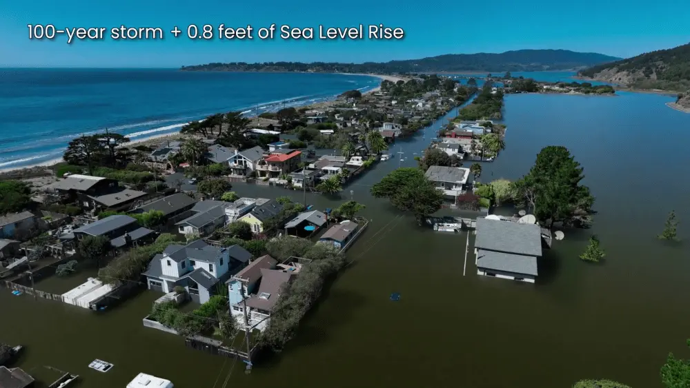
The report estimates that hundreds of homes and other infrastructure are at risk from ocean waves or flooding from Easkoot Creek. “Strong winter storms and sea level rise will continue to erode the beach, flood roadways and impact existing infrastructure, affecting visitation and access to recreational areas,” county officials said in releasing the report. “Nearly half of all Stinson properties are exposed to emergent or shallow groundwater, putting septic and underground utilities at flood risk.”
Stinson got a taste of what could be in store for coastal communities in 2023, when it endured several atmospheric rivers and storm surges. Some properties sustained thousands of dollars in damage, the county reported—and the public beach parking lot was closed for three weeks.
Stinson ARC estimates that just 1 to 2 feet of sea-level rise will flood critical low-lying infrastructure like Highway 1 and utilities.
The Marin County Board of Supervisors will consider next steps for Stinson Beach at its August meeting. The Stinson ARC report can be viewed at marincounty.gov.